

Councillors have approved a major housing blueprint for Bristol with plans for nearly 35,000 new homes by 2040.
The draft Local Plan will go out to public consultation this month with a range of policies to guide how and where property developers build new housing in the city.
New housing developments will be mostly on brownfield urban sites, rather than countryside areas. Lockleaze is the largest site allocation in the north, with about 1,200 more homes planned. Specific sites across the city have been allocated for smaller developments, which the authority hopes will result in builders submitting planning applications and securing the land. Some are vacant but others are in use by businesses.
Councillors sought to find a balance between finding enough land to build enough homes that Bristol needs, while also protecting the local environment.
A cross-party working group took four years to draft the plan, which was voted on during a full council meeting on October 31. After a six-week public consultation, the plan will be sent to government planning inspectors to check its evidence.
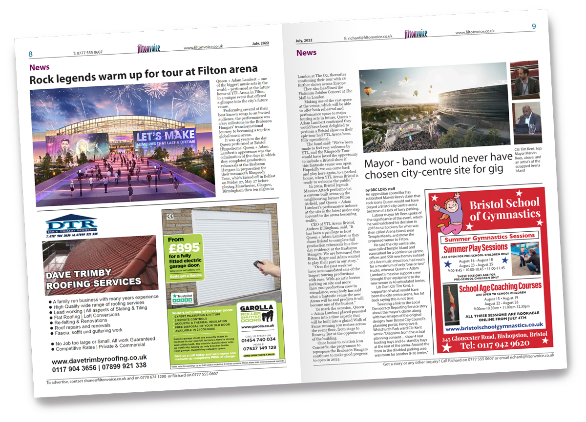
During the council meeting, Bristol mayor Marvin Rees said: “We got 42 square miles, we’re not getting any more land, we’re 472,000 people and one of the fastest growing cities outside London. Our population is predicted to be 550,000 by 2050. There are over 20,000 households on our waiting list and 1,300 households in temporary accommodation.
“This Local Plan offers us a blueprint for the city’s future. It will be used to guide decisions on planning applications. At the heart of the plan is the drive to deliver 34,650 new homes by 2040. It’s been an incredibly challenging piece of work.”
By Adam Postans, Local Democracy Reporting Service
\
bishopston and ashley down
Location: land at Gloucester Road / Merton Road, Horfield
Site description: the site is currently a mix of leisure uses and workspace.
site area: 1.2 hectares
Proposed allocation: comprehensive development for residential-led mixed uses, which incorporates flexible workspace and community uses, if no longer required in its current use.
Estimated capacity of 100 homes. this is likely to be a maximum as it is proposed to provide a mix of uses.
Central
Location: The Grove Car Park, The Grove and Prince Street, Harbourside
Site description: The site is currently in use as a car park, offices, workshop, café and bike shop.
Site area: 0.5 hectares
Proposed allocation: Site would be considered appropriate for a number of city centre uses, including housing to create a more efficient use of land.
Location: Land at Redcliffe Way
Site description: The site covers a central area of the city accommodating a variety of uses including Redcliffe Wharf, road infrastructure, Chatterton’s House and car parking.
Site area: 3.15 hectares
Proposed allocation: On appropriate sites the area would be suitable for residential-led growth, supported by a mix of uses including offices, community infrastructure, leisure uses and culture / tourism uses, which may include hotel uses. An element of retail will be acceptable on appropriate sites subject to consideration of its impact on other designated shopping areas.
Location: Wapping Wharf, Wapping Ward
Site description: The site comprises cleared land that is being brought forward in phases for a mixed-use development.
Site area: 3.45 hectares
Proposed allocation: Housing/offices.
Estimated capacity of 600 homes.
Location: Land to the west of Lodge Street
Site description: The site comprises long-term vacant land adjacent to Trenchard Street car park.
Site area: 0.1 hectares
Proposed allocation: Housing, specialist student accommodation.
Estimated capacity of 20 homes
Location: 55-59 St Michael’s Hill
Site description: The site comprises long-term vacant land within the historic frontage of St Michael’s Hill.
Site area: 0.06 hectares
Proposed allocation: Housing, specialist student accommodation, educational use.
Estimated capacity of 15 homes.
Location: Old Seaman’s Chapel, Royal Oak Avenue, fronting Princes Street
Site description: The site comprises a long-term vacant former chapel and commercial premises.
Site area: 0.02 hectares
Proposed allocation: Office/Workspace/Leisure/Housing.
Location: 16 Narrow Quay
Site description: The site comprises long-term vacant land within the historic frontage of Narrow Quay.
Site area: 0.03 hectares
Proposed allocation: Office/Workspace/Leisure/Housing.
Location: 97-101 Stokes Croft
Site description: The site comprises long-term vacant commercial buildings and land to the rear.
Site area: 0.07 hectares
Proposed allocation: Housing.
Estimated capacity of 20 homes.
Location: 27-33 Jamaica Street
Site description: The site comprises partially cleared land within the historic frontage of Jamaica Street.
Site area: 0.02 hectares
Proposed allocation: Arts and Cultural/Housing/Offices.
Estimated capacity of five homes.
Location: Land and buildings at Victoria Street / Temple Street
Site description: The site comprises office buildings and an historic public house.
Site area: 0.59 hectares
Proposed allocation: Housing/Offices.
A comprehensive solution will be encouraged to the development of the site. Opportunities should be explored to narrow Temple Street closer to its historic alignment, create a new public space to the northwest of Temple Church and reinstate a flatiron building to the corner of Victoria Street and Temple Street.
Location: Railway Cutting, Lower Guinea Street
Site description: The site comprises a former railway cutting used for parking.
Site area: 0.17 hectares
Proposed allocation: Offices/Workspace/Leisure.
Location: The Bell and adjoining buildings, Prewett Street
Site description: The site comprises long-term vacant commercial buildings.
Site area: 0.13 hectares
Proposed allocation: Housing/Pub and Housing.
Estimated capacity of 15 homes.
clifton
Location: 2-16 Clifton Down Road, Clifton
Site description: the site is a cleared, previously vacant retail parade.
Site area: 0.1 hectares
Proposed allocation: mixed use with active ground flood uses including retail, and offices and / or residential uses on upper floors.
Estimated capacity of 10 homes.
clifton down
location: land west of Hampton Lane, Site description: the land is currently characterised as an underused backland, with parking/yards, garages and other small outbuildings.
Site area: 0.3 hectares
proposed allocation: housing, which may incorporate compatible workspace, if no longer required in its current use.
estimated capacity of up to 10 homes.
location: land at Whiteladies Gate, Cotham
Site description: land is currently in use as a builders’ merchant yard.
site area: 0.2 hectares
proposed allocation: housing, which may incorporate compatible workspace, if no longer required in its current use.
estimated capacity of 10 homes.
Location: land adjacent to alma vale road and alma court, clifton
Site description: land is currently in use for car parking.
Site area: 0.1 hectares
proposed allocation: housing, if no longer required in its current use.
estimated capacity of 10 homes.
location: Barley House, Oakfield Grove, Clifton
Site description: land is currently in use as offices.
Site area: 0.1 hectares
Proposed allocation: housing, which may incorporate compatible workspace.
estimated capacity of 20 homes, subject to the suitability of converting the listed building.
cotham
Location: Land at Gibson Road, Cotham
site description: land is currently in use as garages and former outbuildings.
site area: 0.6 hectares
Proposed allocation: housing, if no longer required in its current use.
estimated capacity of 10 homes.
Location: land at Sydenham Lane, Cotham
Site description: land is currently in use as garages and former outbuildings.
Site area: 0.3 hectares
Proposed allocation: housing, if no longer required in its current use.
estimated capacity of 10 homes.
redland
Location: land south of Zetland Road, Redland
Site description: land is currently in use as a garage and car-parking.
site area: 0.2 hectares
Proposed allocation: housing, which may incorporate compatible workspace, if no longer required in its current use.
estimated capacity of 10 homes.
location: land at cossins road, redland
Site description: land is currently in use as garaging and car parking.
Site area: 0.1 hectares
Proposed allocation: housing, if no longer required in its current use.
estimated capacity of 10-12 homes.
stoke bishop
Location: land at Sanctuary Gardens, sneyd park
Site description: the site is currently vacant and was formerly occupied by pre-cast reinforced concrete housing.
site area: 0.5 hectares
Proposed allocation: housing.
estimated capacity of 20 homes.
westbury-on-trym & henleaze
Location: former St Ursula’s high school, Brecon Road
site description: the site is currently vacant.
site area: 0.8 hectares
Proposed allocation: the site would be appropriate for residential uses.
Estimated capacity of 35 homes, subject to the suitability of converting the listed building.
Location: Coombe House elderly persons’ home, Westbury-on-Trym
Site description: the site comprises cleared land last used as an elderly persons’ home.
Site area: 0.3 hectares
proposed allocation: housing
.Estimated capacity of 15 homes.